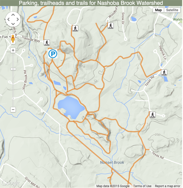
Want Dynamic Google Trail Maps? Have a party!
We conservationists have work parties all the time. We get a crew together and we get a project done. Many hands make light work and all that. It’s how we work.

We’re getting ready to collect GPS data for our local trust and here’s our tentative plan:
Ask for volunteers that have handheld GPSes or phones with GPS tracking apps. Look for multiple volunteers per trail, especially if they are using cellphones. This is where the crowdsourcing comes in — if multiple tracks don’t coincide fairly closely, you have a data problem.
Ask them to collect tracks one trail at a time and to do so on a casual, yet purposeful walk. Collecting tracks isn’t the time to wander off trail, stop for a picnic or guide others on an educational walk. Constant motion is good. Longer trails can be broken into segments. It is easier to have one trail per track file than a bunch of trails in one.
Ask them to separately record the latitude and longitude of parking areas and trailheads and note in the point name which is which. These are useful for markers. Also ask them to note the coordinates of the main entrance to the property (useful for the locator map).
The collection can be done as people have time or, for more fun, by arranging one or more tracking days when groups go out together. This works really well for multi-trail properties where people can track a trail then meet up for lunch when they come back to the starting point.
Have them send the track files in with clear file names that indicate property and trail name.
Note that the widely used file formats are usually best (GPX, GeoJSON, KML, KMZ) as there are converters that can get from these to what you need. We created a simple one here to get from major formats to the abbreviated GeoJSON format we use in Trail Data Manager.
If you’re using Trail Data Manager, simply add the locator points to the properties then create trails with the trailheads and trail tracks and associate the trails with the correct properties.
If you’re not using Trail Data Manager, refer to the Google Maps Javascript API or other mapping software or have a look at a Google Maps plugin for your Content Management System.
Dynamic maps like these don’t work as well in printed trail guides but the GPS track data is also useful for creating topographic maps in most map generation software.
Happy Mapping!